Wednesday, December 8, 2010

Landslide information

Although the information doesn't exactly paint a picture of what happened with the landslide in Colombia, the following information can help us determine what might have caused such a disaster.

Landslide Hazard Information


Landslides cause fatalities and billions of dollars in property damage each year.


Republished from United States Geological Survey Fact Sheet 2004-3072.

Landslides in the United States occur in all 50 States. The primary regions of landslide occurrence and potential are the coastal and mountainous areas of California, Oregon, and Washington, the States comprising the intermountain west, and the mountainous and hilly regions of the Eastern United States. Alaska and Hawaii also experience all types of landslides.

Landslide Incidence and Susceptibility Map
Landslide map
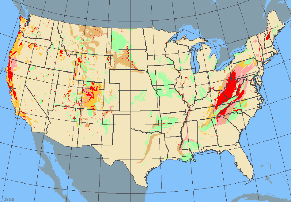
USGS map of relative landslide incidence and susceptiblity across the conterminous United States. Red and pink areas have the highest incidence and susceptibility. USGS Map . Enlarge Image landslide map legend

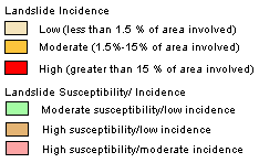
Landslides in the United States cause approximately $3.5 billion (year 2001 dollars) in damage, and kill between 25 and 50 people annually. Casualties in the United States are primarily caused by rockfalls, rock slides, and debris flows. Worldwide, landslides occur and cause thousands of casualties and billions in monetary losses annually.

Landslide Hazard Information

Homeowners Insurance Does Not Cover Landslides

Landslides in the News
The information presented here provides an introductory primer on understanding basic scientific facts about landslides-the different types of landslides, how they are initiated, and some basic information about how they can begin to be managed as a hazard.


Types of Landslides


The term "landslide" describes a wide variety of processes that result in the downward and outward movement of slope-forming materials including rock, soil, artificial fill, or a combination of these. The materials may move by falling, toppling, sliding, spreading, or flowing. The drawing below is a graphic illustration of a landslide, with the commonly accepted terminology describing its features.

Anatomy of a Landslide
Landslide anatomy
Figure 1. An idealized slump-earth flow showing commonly used nomenclature for labeling the parts of a landslide. Enlarge Image

Although landslides are primarily associated with mountainous regions, they can also occur in areas of generally low relief. In low-relief areas, landslides occur as cut-andfill failures (roadway and building excavations), river bluff failures, lateral spreading landslides, collapse of mine-waste piles (especially coal), and a wide variety of slope failures associated with quarries and open-pit mines. The most common types of landslides are described and illustrated at right.


Slides


Although many types of mass movements are included in the general term "landslide," the more restrictive use of the term refers only to mass movements, where there is a distinct zone of weakness that separates the slide material from more stable underlying material. The two major types of slides are rotational slides and translational slides. Slide types, images and descriptions at right.


Flows


There are five basic categories of flows that differ from one another in fundamental ways. Flow types, images and descriptions at right.

Although there are multiple types of causes of landslides, the three that cause most of the damaging landslides around the world are these:


Landslides and Water


Slope saturation by water is a primary cause of landslides. This effect can occur in the form of intense rainfall, snowmelt, changes in ground-water levels, and waterlevel changes along coastlines, earth dams, and the banks of lakes, reservoirs, canals, and rivers.

Landsliding and flooding are closely allied because both are related to precipitation, runoff, and the saturation of ground by water. In addition, debris flows and mudflows usually occur in small, steep stream channels and often are mistaken for floods; in fact, these two events often occur simultaneously in the same area.

Landslides can cause flooding by forming landslide dams that block valleys and stream channels, allowing large amounts of water to back up. This causes backwater flooding and, if the dam fails, subsequent downstream flooding. Also, solid landslide debris can "bulk" or add volume and density to otherwise normal streamflow or cause channel blockages and diversions creating flood conditions or localized erosion. Landslides can also cause overtopping of reservoirs and/or reduced capacity of reservoirs to store water.


Landslides and Seismic Activity


Many mountainous areas that are vulnerable to landslides have also experienced at least moderate rates of earthquake occurrence in recorded times. The occurrence of earthquakes in steep landslide-prone areas greatly increases the likelihood that landslides will occur, due to ground shaking alone or shaking- caused dilation of soil materials, which allows rapid infiltration of water. The 1964 Great Alaska Earthquake caused widespread landsliding and other ground failure, which caused most of the monetary loss due to the earthquake. Other areas of the United States, such as California and the Puget Sound region in Washington, have experienced slides, lateral spreading, and other types of ground failure due to moderate to large earthquakes. Widespread rockfalls also are caused by loosening of rocks as a result of ground shaking. Worldwide, landslides caused by earthquakes kill people and damage structures at higher rates than in the United States.


Landslides and Volcanic Activity


Landslides due to volcanic activity are some of the most devastating types. Volcanic lava may melt snow at a rapid rate, causing a deluge of rock, soil, ash, and water that accelerates rapidly on the steep slopes of volcanoes, devastating anything in its path. These volcanic debris flows (also known as lahars) reach great distances, once they leave the flanks of the volcano, and can damage structures in flat areas surrounding the volcanoes. The 1980 eruption of Mount St. Helens, in Washington triggered a massive landslide on the north flank of the volcano, the largest landslide in recorded times.


Landslide Mitigation -
How to Reduce the Effects of Landslides


Vulnerability to landslide hazards is a function of location, type of human activity, use, and frequency of landslide events. The effects of landslides on people and structures can be lessened by total avoidance of landslide hazard areas or by restricting, prohibiting, or imposing conditions on hazard-zone activity. Local governments can reduce landslide effects through land-use policies and regulations. Individuals can reduce their exposure to hazards by educating themselves on the past hazard history of a site and by making inquiries to planning and engineering departments of local governments. They can also obtain the professional services of an engineering geologist, a geotechnical engineer, or a civil engineer, who can properly evaluate the hazard potential of a site, built or unbuilt.

The hazard from landslides can be reduced by avoiding construction on steep slopes and existing landslides, or by stabilizing the slopes. Stability increases when ground water is prevented from rising in the landslide mass by (1) covering the landslide with an impermeable membrane, (2) directing surface water away from the landslide, (3) draining ground water away from the landslide, and (4) minimizing surface irrigation. Slope stability is also increased when a retaining structure and/ or the weight of a soil/rock berm are placed at the toe of the landslide or when mass is removed from the top of the slope.

Interesting study on Alaskan wildfires

Accelerated Wildfires Unlocking Carbon in Alaskan Soils, Study Finds

December 06, 2010 - News Release
forest fire
Photo Credit:NRCan-CFS
Climate change is causing wildfires to burn more fiercely, pumping more greenhouse gases into the atmosphere than previously thought, according to a new study to be published in Nature Geosciences this week.
This is the first study to reveal that fires in the Alaskan interior - an area spanning 18.5 million hectares - have become more severe in the past 10 years, and have released much more carbon into the atmosphere than was stored by the region’s forests over the same period.
“When most people think of wildfires, they think about trees burning, but most of what fuels a boreal fire is plant litter, moss and organic matter in surface soils,” said University of Guelph professor Merritt Turetsky, lead author of the study.
“These findings are worrisome because about half the world’s soil carbon is locked in northern permafrost and peatland soils. This is carbon that has accumulated in ecosystems a little bit at a time for thousands of years, but is being released very rapidly through increased burning.”
The results of this study are important for countries currently meeting in Mexico for climate talks, added the integrative biology professor.
“Essentially this could represent a runaway climate change scenario in which warming is leading to larger and more intense fires, releasing more greenhouse gases and resulting in more warming. This cycle can be broken for a number of reasons, but likely not without dramatic changes to the boreal forest as we currently know it.”
This study is part of a growing body of evidence that northern systems are bearing the brunt of climate change, said co-author Jennifer Harden, a U.S. Geological Survey scientist.
“This includes longer snow-free seasons, changes in vegetation, loss of ice and permafrost, and now fire, which is shifting these systems from a global carbon sink toward a carbon source.”
The researchers visited almost 200 forest and peatland sites shortly after blazes were extinguished to measure how much biomass burnt.
“We’ve been chasing fires in this region for a number of years, which is how we amassed this unique data set,” said Turetsky.
They also looked at fire records kept since the 1950s.
“Over the past 10 years, burned area has doubled in interior Alaska, mostly because of increased burning late in the fire season,” said co-author Eric Kasischke, a University of Maryland professor. “This is the first study that has demonstrated that increases in burned area are clearly linked to increases in fire severity. This not only impacts carbon storage, but also will accelerate permafrost loss and changes in forest cover.”
More severe burning also raises a number of health concerns, as fire emissions contain mercury and particulate matter that can cause respiratory issues, said Turetsky.
“We are hoping people will recognize the seriousness of climate change for northern regions and people living in them. Wildfire is going to play a more and more important role in shaping the north.”

Landslide kills nearly 50 in Colombia

Colombia news - Bello
Rescue workers in the town of Bello where a landslide on Sunday destroyed 35 houses have recovered 47 bodies from the rubble, authorities announced on Wednesday. 80 people are still missing.
Following a short suspension of the work because of heavy rains, policemen, soldiers and Red Cross volunteers returned to look for victims early Wednesday morning, which resulted in the finding of eight more victims.
So far, at least 22 children were recovered from under the rubble.
Mourning family members and friends of victims of the landslide in the town just north of Medellin started burying their loved ones on Tuesday following a mass service in the local church.


 Related story below:


Colombia's President Juan Manuel Santos declared a state of emergency to cope with the catastrophe caused by this year's rainy season, which has killed more than 200, uprooted thousands of families, and affected more than 1.6 million Colombians.
"Tonight we are taking the decision to firstly declare a disaster situation [in the town of Bello] and secondly declare an economic, social and ecological emergency ... initially for 30 days, but it can be extended to 90 days," the president said in a televised speech after returning from the town just north of Medellin where a landslide is feared to have killed 124 residents of a poor hillside slum.
The state of emergency will allow the government to take a number of measures in the short, medium and long term and will consist of three phases, said Santos.
"The first will be dedicated to humanitarian aid, as in saving lives and providing shelter and food to the approximately 330,000 families that need this. The second will be a phase of rehabilitation to repair the roads, schools, power networks and other infrastructural works that must be recovered. The third phase - which will be the biggest and most ambitious of all - will be reconstruction, which implies the repair of everything that has been destroyed or has become useless," the president said.
Santos explained that he and his ministers decided to declare the emergency because the gravity of the situation in Colombia has exhausted the government's capacity. According to the president, Bogota has already invested COP0.5 trillion ($264 million) in attending to the problems caused by the extended rainy season. "The needs go beyond our economic capacity and have also flooded the agencies specialized in disaster attention," said Santos.
This year's extended rainy season - caused by weather phenomenon "La Niña" - started in March and has devastated the country. According to the government, 80% of the country's roads are damaged, more than 200 persons are confirmed killed by floods and landslides, 1.6 million people have suffered damage to their homes or lands, and many hectares of crops were lost in floods.
To help mitigate the effects of the disastrous rainy season, the U.S. ambassador to Bogota on Tuesday announced his country will donate a total of $1 million to the Colombian branch of the Red Cross to provide immediate help to victims. The Inter-American Development Bank (IDB) offered Colombia a $350 million loan, and United Nations Secretary General Ban-Ki Moon promised to "do everything possible to help."

Colombia's Consul General in Miami opened a number of U.S. bank accounts and a PayPal account where foreigners and migrants can donate money. Colombia's embassy in Washington is working on its website to allow donations to be given directly through the website. Several social organizations in the U.S. and Colombia are also looking for donations.


The above stories came from Columbiareports.com after a landslide destroyed homes and killed nearly 50 people. Probably the more interesting of the two is the bottom story, which discusses the government's response to the disaster. As we learned in class, declaring a state of emergency means money for the areas damaged - although in this case it sounds like it is coming from places other than the government. Although the article discusses the heavy rainy, it would have been interesting to read a little bit more about the specifics of what caused the landslide.

Monday, November 15, 2010

Toxic sludge

This is, of course, a blog set up for an environmental hazards class. However, in the case of the toxic spill that has reached the Danube River, I feel that even this man-made disaster is worth attention.  In my opinion there is nothing worse than completely disrupting natural processes and ecosystems - not to mention killing innocent people - either because of the ignorance of businesses. The first question that comes to mind is why a plant that hold mercury or arsenic is anywhere near a river in the first place? I would assume people have known the harmful effects of both chemicals long to know that such a plant should not be allowed near a river that could carry even small amounts of those substances down river to destroy fish populations and potentially sicken people along the river who are exposed to it. An interesting point worth noting in the article below is about how much the Danube has been diverted and changed from its natural flow for navigation purposes. Engineering obviously was a big part of this disaster, and most likely will be the source of other disasters on river that is struggling with the impacts of human development.

A Hungarian fire fighter cleans a street flooded with toxic mud in Devecser, Hungary, Thursday, Oct. 7, 2010. The toxic red sludge that inundated three Hungarian villages reached Europe's mighty Danube River on Thursday but no immediate damage was evident, Hungary's rescue operations agency said. The European Union and environmental officials had feared an environmental catastrophe affecting half a dozen nations if the red sludge, a waste product of making aluminum, contaminated Europe's second-longest river after bursting out of a factory's reservoir. (AP Photo/Darko Bandic)
A Hungarian fire fighter cleans a street flooded with toxic mud in Devecser, Hungary, in early October.
Photograph by Darko Bandic, AP
Ker Than
Published October 12, 2010
This story is part of a special news series on global water issues.
The recent reservoir failure that flooded several towns in Hungary with toxic red mud is the latest environmental insult to Europe's Danube River. But it is not the first, nor the worst, disaster of its kind, experts say. (See photos of the mud spill.)

And unless steps are taken to safeguard similar industrial plants and mining facilities around the world, these kinds of accidents will continue to happen, they warn.

On October 4, a so-called tailing dam that held waste products, including arsenic and mercury, from the Ajkai Timfoldgyar aluminum-processing plant in the town of Ajka, Hungary, collapsed. This released an estimated 184 million gallons (697 million liters) of highly alkaline red mud into the Marcal River and nearby towns, killing at least eight people. The toxic flood reached the Danube River—Europe’s second-largest river—last Thursday, sparking fears of downstream contamination.

The Degraded Danube

Hungary Prime Minister Viktor Orban called the spill the country's biggest ecological disaster. But other government officials say there has been no serious impact on the Danube's wildlife because the sludge's toxic substances have been safely diluted by the river—a claim that Greenpeace and other environmental groups have been quick to question.

"To say it's not creating any environmental impact at all would be misleading, but whether those impacts are devastating, it doesn't appear that they are," said Jim Kuipers, a mining-engineering consultant based in Butte, Montana.

The Hungary spill is the latest in a long list of environmental problems affecting the Danube River, including pollution from cities and industry and pesticides and chemical runoff from farms.

"It's sort of like having a bad backache and then having your kid jumping on you," said Emily Stanley, a freshwater scientist at the University of Wisconsin, Madison. "It's an acute injury to a chronically stressed system."

One of the biggest threats facing the Danube today is human alterations to the river made for navigation purposes, according to a 2004 European Commission report. Projects to deepen, dam, or straighten the river and remove "bottlenecks" to vessel passage are changing the river's traditional floodplain landscape and water flow into deltas, as well as destroying wetlands and other protected habitats, according to the environmental nonprofit WWF.

There are currently projects underway to restore the Danube's floodplains, and a recent plan by the International Commission for the Protection of the Danube River (ICPDR) aims to halt the illegal dumping of hazardous materials into the river.

Making Mining Safer?

The total discharge from the dam failure in Hungary is nearly equal to the 200 million gallons (750 million liters) of oil spewed into the Gulf of Mexico from the leaking BP oil well this year. But comparing the two disasters is neither fair nor accurate, Kuipers said.

"The immediate devastation of this dam failure is in a relatively small area, and we haven't seen huge widespread ecological impacts from it," he said.

"But in the Gulf, the widespread impacts are pretty much indisputable, and it's going to cost tens of billions of dollars to clean up. It's not going to cost tens of billions of dollars to deal with the ecological impact of this spill."

But even if the environmental costs from the tailing-dam spill are still unclear, the toll in human life is already too high, Kuipers said.

"If only one person is killed, it's one person too many," he added. "It points to very lax [dam-building] standards in the country as a whole."

Hungary is not unique in this regard, however, said the University of Wisconsin’s Stanley.

“In Eastern Europe in particular, there are a lot of these dams and facilities that are not receiving any kind of oversight any more," she said. "The money is short and the government has just walked away."

Some experts estimate that the rate of tailing-dam failures worldwide is nearly ten times higher than that of typical water dams—and with many of those dams located near rivers and streams, the potential for environmental damage to waterways is high.

For example, if the Akja aluminum plant tailings contained cyanide instead of less toxic arsenic and mercury, the impact on wildlife could have been much worse.

In 2000, just such a spill occurred in Romania when a tailing dam from a gold mine burst, spilling cyanide-laced water into the Tisza and Danube rivers and killing up to 80 percent of aquatic life along some stretches.

Scientists and environmental groups worry that as mining projects grow larger, the tailing dams built to serve them will pose increasingly larger threats should they fail.

For example, a tailing dam proposed for the headwaters of Bristol Bay, Alaska, would be among the largest dam of any kind in the world. If that dam were to break, "the scale of what happened in Hungary will seem like child's play," said Alan Septoff, research director of Earthworks, a nonprofit environmental group based in Washington, D.C.

Another concern is the large number old tailing-dams that are aging without proper maintenance or repair.

"Dams are like baby boomers," the University of Wisconsin's Stanley said. "They get old, they age, and they begin to show signs of deterioration. Without inspection and regular repairs and maintenance, I think it's highly likely that we'll see more of these [failures] in the future."

Fortunately, the mining industry has demonstrated that it’s capable of change, she said. The bad news is that it has sometimes required a catastrophe to do so. For example, in 2008, a tailing dam rupture at the TVA Kingston Fossil Plant in Tennessee released more than 1.1 billion gallons (6.8 billion gallons) of coal fly ash flurry—a byproduct of coal combustion—into the Emory River.

"As a result, the U.S. Environmental Protection Agency and others immediately undertook an evaluation of all similar facilities in the United States," Kuipers said.

"In the same way, the [Hungary spill] is a call for similar facilities throughout the world to undergo inspection and change their operational situation to prevent this type of event from occurring."

Stanley is similarly hopeful. "Maybe this is a difficult thing for Hungary, but a wake-up call or the rest of the world about managing these wastes," she said.

More on tsunamis

It's been a challenge (at least for me) to find current events-type content this week. However, I did find this interesting and very easy to read chart on what causes tsunamis. Check it out:

http://geology.com/articles/tsunami-geology.shtml

Monday, November 8, 2010

More on Mount Merapi

Eruption at Mount Merapi, Indonesia

Below is an article from http://www.geology.com/. The text gives a little bit of insight into the importance of the volcano and its hitory. But more importantly, the graphic tells us more about what kind of volcano it is, how it erupted and what surrounding areas face the most danger.

The steep-sided, cone-shaped Mount Merapi volcano is both boon and curse to the people of Indonesia. Volcanic ash from its frequent eruptions makes the soil fertile enough to support a large population. It is also one of Indonesia’s most active volcanoes, posing a constant threat to tens of thousands of people who live in its shadow. On October 26, 2010, the volcano once again turned destructive, unleashing a series of eruptions that had killed at least 44 people and forced 75,000 people from their homes, said CNN on November 4.
The mountain has been shrouded in clouds throughout the eruption, but on October 30 the Advanced Spaceborne Thermal Emission and Reflection Radiometer (ASTER) on NASA’s Terra satellite captured the thermal signature of hot ash and rock and a glowing lava dome. The thermal data is overlaid on a three-dimensional map of the volcano to show the approximate location of the flow. The three-dimensional data is from a global topographic model created using ASTER stereo observations.
The Center of Volcanology and Geological Hazard Mitigation reported that two pyroclastic flows moved down the volcano on October 30. A pyroclastic flow is an avalanche of extremely hot gas, ash, and rock that tears down the side of a volcano at high speeds. ASTER imaged one of those flows.
Merapi shows no signs of slowing. After several days of eruptive episodes, the volcano began an eruption on November 3 that was five times more intense than on October 26 and lasted more than 24 hours. It is the most violent eruption at the volcano since the 1870s, said local geologists.

Sunday, November 7, 2010

Looks like more dead in Indonesia ...

MOUNT MERAPI, Indonesia — The tiny hospital at the foot of Indonesia's most volatile volcano is struggling to cope with victims brought in after the mountain's most powerful eruption in a decade. Some have clothes, blankets and even mattresses fused to their skin.
With few beds and the only burn unit in town, doctors are forced to turn some people away.
A surge of searing gas raced down the sides of Mount Merapi on Friday, smothering entire villages as it killed or seriously burned those caught in its path. The death toll after the volcano's largest eruption in a century soared to 122.
The worst hit village of Bronggang lay nine miles from the fiery crater, just on the perimeter of the government-delineated "danger zone." Crumpled roofs, charred carcasses of cattle and broken chairs — all layered in white ash and soot — dotted the smoldering landscape.
The zone has since been expanded to a ring 12 miles from the peak, bringing it to the edge of the ancient royal capital of Yogyakarta, which has been put on its highest alert. Poor visibility from dust showers forced closed the city's airport for a second day Friday.
Officials say the biggest threat to residents is the Code River, which flows from the 9,700-foot mountain into the heart of the city of 400,000 and could act as conduit for deadly volcanic mudflows that can race at speeds of 60 mph.
The river is already clogged with cold lava, mud, rocks and other debris.
Sri Sucirathasri said her family had stayed in their Bronggang home Thursday night because they hadn't been told to leave.
They awoke in the dark as the mountain let out thunderous claps and tried desperately to outrun the flows on a motorbike. Her mother, father and 12-year-old sister, Prisca, left first, but with gray ash blocking out any light, they mistakenly drove into — rather than away from — the volcano's dangerous discharge.
The 18-year-old Sri went looking for them when she heard her mother's screams, leaving at home an older sister, who died when the house was engulfed in flames.
"I don't know what to say," she whispered when asked if she blamed officials for not warning the family. "Angry at who? I'm just sad. And very sick."
Merapi's latest round of eruptions began Oct. 26, followed by more than a dozen other powerful blasts and thousands of tremors.
With each new eruption, scientists and officials have steadily pushed the villagers who live along Merapi's fertile slopes farther from the crater. But after initially predicting earlier eruptions would ease pressure under the magma dome, experts who have spent a lifetime studying the volcano now say the don't know what to expect.
Scientists can study the patterns of volcanoes, but their eruptions are essentially unpredictable, as Merapi's increasingly intense blasts have shown.
Towering plumes of ash rained dust on windshields of cars 300 miles away Friday, although rain near the mountain in the afternoon turned much of it to sludge. Bursts of hot clouds occasionally interrupted aid efforts, with rescuers screaming, "Watch out! Hot cloud!"
The latest eruption released 1,765 million cubic feet of volcanic material, making it "the biggest in at least a century," state volcanologist Gede Swantika said as plumes of smoke continued to shoot up more than 30,000 feet.
Soldiers pulled at least 78 bodies from homes and streets blanketed by ash up to a foot deep, raising the overall toll to 122, according to the National Disaster Management Agency.
With bodies found in front of houses and in streets, it appeared that many of the villagers died from the blistering gas while trying to escape, said Col. Tjiptono, a deputy police chief.

Friday, October 29, 2010

Sinkhole causing concern at dam in Ladysmith

Below is a story from the Leader-Telegram and Associated Press. I found this particularly interesting because of the damage that could occur all along the river if the dam fails. The news stories haven't been very detailed, so it's hard to get a grasp how big the sinkhole is and potential threats it poses. But other stories reported that the river is up 7 feet in Eau Claire because of controlled water release upstrem to relieve pressure on this dam, so  I have to imagine if something went wrong, many people could be affected.


LADYSMITH - The National Weather Service has issued a flash flood warning for residents downstream of the Big Falls Hydro Dam near Ladysmith after a sink hole was developing at the dam.
Xcel Energy Tuesday advised the service that there was potential for a dam failure. The company is keeping a round-the-clock watch on the dam near Ladysmith after a small sinkhole developed in an earthen embankment.
The utility implemented a watch condition for potential dam failure Tuesday as rain fell in western Wisconsin.
Xcel spokeswoman Liz Wolf Green says the sinkhole was discovered in an embankment to the east of the powerhouse.
As a precaution, Xcel is lowering the reservoir 6 inches an hour for 24 hours, to bring the water level down by 12 feet and relieve pressure.
There are no evacuations, the the weather service said a flash flood warning would be issued if dam failure was imminent.
The dam is located on the Flambeau River about seven miles north and east of Ladysmith. The flash flood watch extends from the dam to the Rusk County airport.

More than 400 dead as result of volcano, tsunami in Indonesia

Below is an article about the aftermatch of a volcano eruption and tsunami in Indonesia. As I read the story, I instantly found it easy to look at the event using the complexity paradigm. The sequence of events in this disaster clearly show that they are part of a much larger picture of activity. Both tsunamis and volcanic eruptions originate with tectonic activity. So it is not surprising that Indonesia fell victim to such an event, as it lies on plate boundary that also happens to be a part of the Ring of Fire.
 
Gembong Nusantara A villager walks past a buffalo killed in Mount Merapi eruption in Kinahrejo, Yogyakarta, Indonesia, Wednesday, Oct. 27, 2010. A volcanic eruption and a tsunami killed scores of people hundreds of miles apart in Indonesia, spasms from the Pacific Ring o
Posted: Friday, October 29, 2010 12:00 am
MENTAWAI ISLANDS, Indonesia (AP) - The fisherman was jolted awake by the powerful earthquake and ran with his screaming neighbors to high ground. He said they watched as the sea first receded and then came roaring back "like a big wall" that swept away their entire village.
"Suddenly trees, houses and all things in the village were sucked into the sea and nothing was left," Joni Sageru recalled Thursday in one of the first survivor accounts of this week's tsunami that slammed into islands off western Indonesia.
The death toll rose today to 393 as officials found more bodies, although hundreds of people remained missing. Harmensyah, head of the West Sumatra provincial disaster management center, said rescue teams "believe many, many of the bodies were swept to sea."
Along with the 33 people killed by a volcano that erupted Tuesday more than 800 miles to the east in central Java, the number of dead from the twin disasters has now reached 426.
After a lull that allowed mourners to hold a mass burial for victims, Mount Merapi started rumbling again Thursday with three small eruptions and another one early today. There were no reports of new injuries or damage.
The catastrophes struck within 24 hours in different parts of the seismically active country, severely testing Indonesia's emergency response network.
Aid workers trickling into the remote region found giant chunks of coral and rocks in places where homes once stood. Huge swaths of land were submerged. Swollen corpses dotted roads and beaches.
In a rare bright spot, an 18-month-old baby was found alive Wednesday in a clump of trees on Pagai Selatan - the same island where the 30-year-old Sageru lived. Relief coordinator Harmensyah said a 10-year-old boy found the toddler, whose parents are both dead.
More than 100 survivors crowded a makeshift medical center in the main town of Sikakap on Pagai Utara - one of the four main islands in the Mentawai chain located between Sumatra and the Indian Ocean.
Officials say a multimillion-dollar tsunami warning system that uses buoys to detect sudden changes in water levels broke down a month ago because it was not being properly maintained. The system was installed after a monster 2004 quake and tsunami that killed 230,000 people in a dozen countries.
A German official at the project disputed there was a breakdown, saying Monday's 7.7-magnitude quake's epicenter was too close to the Mentawai islands for residents to get the warning before the killer wave hit.
"The early warning system worked very well - it can be verified," said Joern Lauterjung, head of the German-Indonesia Tsunami Early Warning Project for the Potsdam-based GeoForschungs Zentrum. He added that only one sensor of 300 had not been working and said that had no effect on the system's operation.
At the Mount Merapi volcano, hot clouds of ash spewed from the mountain at 6:10 a.m. today, according to the Indonesian volcanology agency Subandriyo.
It was unclear whether the new activity was a sign of another major blast to come.
A young woman named Adek sobbed uncontrollably as she tried to talk about her year-old baby who was washed away. "Oh, don't ask me again," she said, wiping her tears and turning away.
One of the hardest hit areas with 65 dead was the village of Pro Rogat, on Pagai Seatandug island.
Villagers there huddled under tarps in the rain and told how many people who had fled to the hills were now too afraid to return home.
Mud and palm fronds covered the body of the village's 60-year-old pastor, Simorangkir. He lay on the ground, partially zipped into a body bag. Police and relatives took turns pushing a shovel into the sodden dirt next to him for his grave.
His 28-year-old grandson, Rio, traveled by boat to Pro Rogat from his home on a nearby island to check on his relatives after the quake and tsunami. He said he was picking through the wreckage when someone cried out that he had found a body.
Rio walked over and saw the face of his dead grandfather, partially buried under several toppled palm trees, looking back at him.
"Everybody here is so sad," Rio said, as relatives prepared to lay his grandfather in the grave.
Residents from Kinahrejo, Ngrangkah, and Kaliadem - villages that were devastated in Tuesday's blast - crammed into refugee camps. Officials brought cows, buffalo and goats down the mountain so that villagers wouldn't try to go home to check on their livestock.
Thousands attended a mass burial for 26 of the victims six miles (10 kilometers) from the base of the volcano. Family and friends wept and hugged one another as the bodies were lowered into the grave in rows.
---
Associated Press writers Achmad Ibrahim in the Mentawai islands, Slamet Riyadi at Mount Merapi and Irwan Firdaus in Jakarta contributed to this report.


Friday, October 22, 2010

More earthquakes near or in Haiti likely

From the US Geological survey:

The January 2010 M7.0 earthquake that devastated Haiti’s economy and caused over 200,000 casualties also resulted in significant uplift of the ground surface along Haiti’s coastline, and involved slip on multiple faults, according to a study published online in Nature Geoscience.
Because the earthquake did not involve slip near the surface of the Earth, the study suggests that it did not release all of the strain that has built up on faults in the area over the past two centuries, and so future surface rupturing earthquakes in this region are likely.
The paper also suggests that similar events may be hidden from the prehistoric earthquake record both in Haiti and in other similar tectonic settings such as the San Andreas fault in California.
Gavin Hayes, a U.S. Geological Survey geophysicist, along with colleagues from USGS, California Institute of Technology, NASA's Jet Propulsion Laboratory (JPL), and the University of Texas at Austin, used a combination of seismological observations, geologic field data and satellite geodetic measurements to analyze the earthquake source. Initially the Haiti earthquake was thought to be the consequence of movement along a single fault, which accommodates the motion between the Caribbean and North American plates.
By modeling the patterns of surface deformation, the team was able to assess which fault was responsible. Their results showed that the earthquake may not have been caused by the simple rupture of a single fault, but instead may have involved a complex series of faults.
The pattern of surface deformation was dominated by movement on a previously unknown, subsurface thrust fault, named the Léogâne fault, which did not rupture the surface.
Hayes, a post-doctoral researcher, is contracted to work for the USGS by Synergetics, Inc.
This is one of several papers to be published this month in a special issue of  Nature Geoscience on the Haiti earthquake.

http://www.usgs.gov/newsroom/article.asp?ID=2612&from=rss_home

Friday, October 8, 2010

Wetlands destructing may have made Arcadia flood worse

Below is an interesting story writtend by Doug Erickson of the Wisconsin State Journal, published Oct. 2. It's an interesting arguement that may never be resolved. Had Ashley not built there would the flood have been less damaging? One of the most interesting factors in the story is the amount of jobs created by building Ashley in Arcadia. It seems like you hear that everywhere now ... since the economy is bad, any time jobs will be created it seems like all other concerns fall to the wayside. But are jobs worth the destruction a small town?

buy this photo Canoeists paddle past an Ashley Furniture building in Arcadia Sept. 23, the day the company shut down production due to flooding. DAN REILAND – Associated Press
  • Midwest Flooding
  • Map of Ashley Furniture plant

Related Stories

Flood insurance

Residences and businesses in Arcadia can purchase flood insurance through the National Flood Insurance Program because the city is in a flood-prone area and its elected officials have agreed to participate in the program, said David Schein, a regional flood insurance liaison with the Chicago office of the Federal Emergency Management Agency.
The federal Privacy Act of 1974 prohibits FEMA from releasing the names of companies or homeowners who participate, he said. An Ashley Furniture spokeswoman said she did not know if the company participates.
Congress created the program in 1968 to encourage community flood plain management and to provide protection for property owners in hard-to-insure areas.
Although the program is backed by the federal government, the insurance is sold through private insurance companies and agents, Schein said. Claims are paid out of a fund that program participants contribute to through their insurance premiums, he said.
After Ashley Furniture received a state permit five years ago to fill in 13.5 acres of wetlands for a factory expansion in Arcadia, opponents warned of environmental consequences.
Wetlands serve as “natural hazard insurance against flooding,” the Wisconsin Wetlands Association said at the time.
So when widespread flooding in Arcadia temporarily closed Ashley Furniture 10 days ago, and photos showed canoeists paddling by a company loading dock, old arguments resurfaced.
“No one can say, ‘If only there had been more wetlands there, this wouldn’t have happened.’ But can we say there would have been less of an impact? Definitely,” said Becky Abel, executive director of the wetlands association.
But Ashley Furniture and the state Department of Natural Resources, which approved the permit, say critics are off base. The water swamping the city is coming primarily from the overflow of two upland creeks, Turton Creek and Meyers Valley Creek, not the adjacent Trempealeau River, they say. The areas of land that drain into those creeks, called watersheds, are several miles east and south of Arcadia, yet the city is at the mercy of the small creeks by being downstream.
“It’s one of those things you can’t plan for,” said Dan Baumann, a regional DNR water leader in Eau Claire who was part of the team that approved the permit. “I don’t know that their filling in of the wetlands would have caused any additional impact.”
The permit area on Ashley’s property “was not, in whole or in part, a cause or a contributing factor to the recent flooding,” said Paulette Rippley, an Ashley Furniture spokeswoman.
Extended debate
The company’s efforts to expand into wetlands played out over more than a decade beginning in the mid-1990s and spurred charges of strong-arm political tactics against Ashley Furniture and of job-killing extremism against environmentalists.
If the permit had not been granted, about 2,000 jobs — “substantially all of Ashley’s Arcadia facilities” — would have been moved to another state, Rippley said this week. The company, based in Arcadia, creates an economic ripple effect in Wisconsin conservatively estimated at more than $270 million annually, she said. The city is about 45 miles northwest of La Crosse.
Even the one-day shutdown of production at the Arcadia plant Sept. 23 hit community members hard.
“They’re the county’s largest employer,” said Dan Schreiner, Trempealeau County emergency management director. “It’s pretty traumatic when they’re not working.”
Ashley Furniture has estimated “uninsured losses and damages” due to the flooding of $3.51 million, according to information the company provided the county on Tuesday. In addition, the company projected $2.75 million in “lost wages by hourly employees and lost sales by local Ashley suppliers.”
Rippley said the company’s information technology building in downtown Arcadia was particularly hard hit. About 100 computer technicians and programmers work there, and a significant amount of computer equipment not covered by insurance was heavily damaged, she said.
Permit approved
Although sympathetic lawmakers initially sought to exempt Ashley Furniture from state wetlands laws, the company ultimately secured permission to fill in the wetlands in 2005 through the regular DNR permitting process.
Parts of the Ashley Furniture complex exist within the Trempealeau River floodplain, and the company followed all rules for building in that flood plain, Baumann said. The problem with this flooding is that the water comes largely from creeks so small their floodplains have not been studied or mapped, he said.
Others say there has been a longtime pattern in the area of incrementally degrading and eliminating wetlands — by Ashley Furniture and others — and that the cumulative effect has made Arcadia more vulnerable to flooding.
“There’s no doubt that at least some potential protection would have been afforded by not filling in so much of that river bottom,” said George Meyer, executive director of the Wisconsin Wildlife Federation and DNR secretary from 1993-2001.
Wetlands “hold a lot of water and release it slowly over time, which reduces the flooding of agricultural and residential areas,” said Keith Reopelle, policy director for Clean Wisconsin. “I think you have to admit that filling in that wetlands area has exacerbated the impact of flooding.”
Ashley Furniture mitigated the loss of the 13.5 acres of wetlands by creating wetlands elsewhere more than double the size. The 34.5-acre project cost Ashley about $1 million and included the planting of 6,400 trees and 43,500 plants, Rippley said.
Also, Ashley improved a dike along Meyers Valley Creek, which likely reduced the amount of recent flooding in Arcadia, and it has assisted the city in improving lift stations to remove flood water, Rippley said.
Abel, of the Wisconsin Wetlands Association, said mitigation programs can be successful, but not this one. The wetlands that were created are in a different watershed than those eliminated, so their function in the watershed around Ashley Furniture was not replaced, she said.

Saturday, October 2, 2010

Preparing for a volcano

I found this article on the USGS site about volcanic activity in the Arabian Desert. I find it really interesting that you don't hear more about these types of events, especially if this many people were evacuated and the potential for danger is so great:

http://www.usgs.gov/newsroom/article.asp?ID=2603&from=rss_home

Wednesday, September 29, 2010

Flooding follow up

A few things to note as the river drops back to its normal levels. First of all, the crest of the river early Sunday morning was the fifth highest in recorded history. Surprisingly though, it caused very little damage, which is interesting considering how much the river has been developed since the last major flood. I don't know the answer to this, but is it possible that developers were smart enough to plan ahead for a such thing? Or was it just not that serious of an event? Also, as we discussed in class cities like Durand were gearing up for the worst of the flood days after the river crested in Eau Claire. It seems obvious enough, but I guess I never really thought about how much worse things can get down stream with all of the tributaries flowing in. Below is a story about how minor the damage was in Eau Claire.

http://www.leadertelegram.com/news/front_page/article_c3722832-cb86-11df-a99e-001cc4c002e0.html

Thursday, September 23, 2010

Is the island moving or isn't it?

Interestingly enough, the outrageous amount of rain that has fallen in the last two days has tied perfectly into yesterday's lecture about media coverage of disasters. Today when I reported to my post at the Leader-Telegram I could have sworn it was the apocalyspe. Rain drenched me on my way in as ambulances screamed down Farwell St. When I got inside, there was shouting over the police scanner and the newsroom was buzzing. For the first time in my four years here I was hearing familiar terms like "100-year flood" being tossed around, and the reporter across from we was asking someone on the phone what the chances were of the Chippewa River rising to record flood levels. And the day kept getting more interesting. A land slide caused the closure of one lane on Highway 53 and apparently someone had reported that an island near the North Crossing was slowly floating down river towards the bridge. The floating island debate went on for at least an hour as our reporter scrambled for confirmation from the police and the Department of Transportation, who later said the island was not moving at all.

First off, this is an incredible event for Eau Claire. Rain, of course, is not out of the norm in the area. But without warning the incredible amounts  have already caused Governer Doyle to declare a state of emergency in Trempealeau Co., and it has caused dangerous situations throughout our own city. The Leader-Telegram's coverage of the storm has thus far hit three of the angles discussed in class yesterday - a story published in today's paper about the possibility of flooding (to warn people) and a story online today about what flooding has recently occured (to inform people). The two stories are posted below:

http://www.leadertelegram.com/news/daily_updates/article_3f004c8e-c710-11df-bb8d-001cc4c002e0.html

http://www.leadertelegram.com/news/front_page/article_b5fac92e-c6cd-11df-8dbf-001cc4c002e0.html

Monday, September 20, 2010

Engineering paradigm

Since I decided I would like to somehow incorporate environmental topics and issues into my journalism career in the future, I thought it would be interesting to subscribe to the EPA's daily alerts on just about everything to keep myself up on what's going on around the country. That explained, the other day I got this e-mail alert:

FOR IMMEDIATE RELEASE
No. 10-OPA111
First grants awarded in Michigan for President's Great Lakes Restoration Initiative
(DETROIT - Sept. 20, 2010) U.S. Environmental Protection Agency today announced more than $2 million in federal grants to three Southeast Michigan organizations at a news conference in William G. Milliken State Park and Harbor, overlooking the Detroit River.  The grants are part of President Obama's Great Lakes Restoration Initiative, a $475 million program that represents the largest investment in the Great Lakes in two decades.
A total of 99 grants for an estimated $63 million are expected to be awarded in Michigan.  Funded projects will advance the goals and objectives of the Great Lakes Restoration Initiative Action Plan which EPA Administrator Jackson announced in cooperation with 15 other participating agencies and the Great Lakes governors in February.
Southeast Michigan Council of Governments was awarded $500,000 for its "Restoring the Lake Erie Corridor Through Green Streets" program. The funds will pay for construction of bioswales, tree trenches and grow zones to manage road runoff; reduction of annual stormwater runoff volumes, sediment and nutrient loading by approximately 50 percent; development of a Great Lakes Green Streets Guidebook transferable to municipalities; and installation of Green Streets signage for public education benefits.
Michigan Department of Natural Resources and Environment will receive $1,028,548 for "Rapid Response to Invasive Species." This project will use the best known methods to eradicate and control several invasive aquatic plant species that harm the Great Lakes. The program will help direct future resources for invasive species control to the most cost-effective, strategic and highest threat locations.
Wayne State University was awarded $519,564 for "Verification of Ballast Water Treatment Technology."  This project is designed to develop technology that will help assess the effectiveness and durability of shipboard ballast water treatment systems.  The applicant is collaborating with a ballast water treatment company to allow testing both in the laboratory and with actual shipboard ballast water operations.
The Great Lakes provide some 30 million Americans with drinking water and underpin a multi-billion dollar economy.  EPA is awarding $475 million in grants for aggressive community-based efforts to address five priorities:
  • Cleaning up toxics and toxic hot spots around the Great Lakes.
  • Combating invasive species.
  • Promoting nearshore health by protecting watersheds from polluted runoff.
  • Restoring wetlands and other habitats.
  • Accountability and working with strategic partners on outreach.
The e-mail made me think of today's lecture and the changing hazard paradigms. While it may be loosely connected, I thought the uses of the various grants mentioned in the above message demonstrated the engineer way of thinking. While it is mostly unlikely that a natural disaster of large magnitude will occur around the Great Lakes, or at least I can't think of many in recent years, it was interesting that some of the funding will go to natural barriers such as tree trenches and grow zones. While those things will help reduce road runoff as noted, they can also help in the prevention of erosion - which could further the safety of surrounding roads and buildings. Who knows? Maybe a big storm with heavy rains could cause disasterous conditions for the foundations of those buildings and roads. Maybe not. But I think that sort of preventative planning could be linked to the engineering paradigm.

Thursday, September 9, 2010

Hello!

Hi Everyone,

Welcome to my blog, which will be used to keep track of environmental hazards throughout the year. I will be posting weekly information on what's happening around the world and how those happenings affect people in the region.

I'm keeping this blog for a geography course in hazards at the University of Wisconsin - Eau Claire. I am 22 years old, and originally from Chippewa Falls, WI. In addition to being a full time print journalism/environmental science student, I work full time as the arts/entertainment editor at the Leader-Telegram, a 20-30,000 circulation newspaper in Eau Claire, Wis.

Rob Hanson
hansonrw@uwec.edu